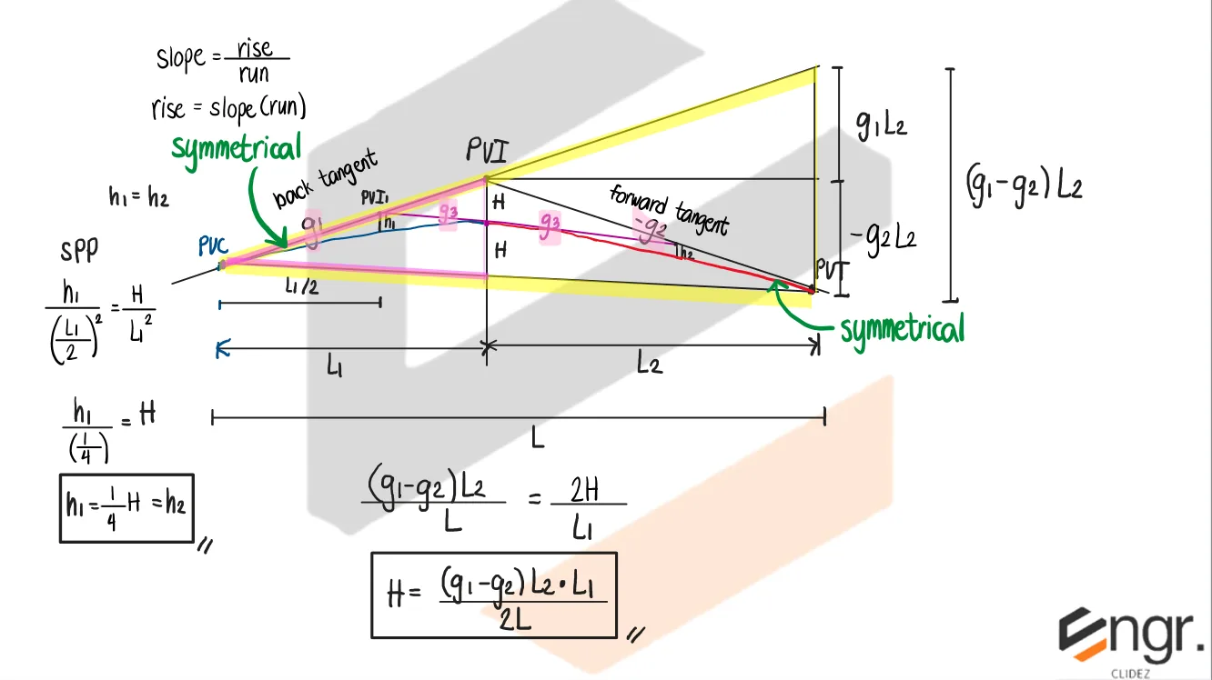
An unsymmetrical parabolic curve is a vertical curve in which the lengths of the curve on either side of the point of vertical intersection (PVI) are not equal. Unlike symmetrical curves—where the PVI lies at the midpoint—an unsymmetrical curve has different distances from the PVI to the beginning (PC) and to the end (PT) of the curve. These curves are commonly used when site constraints, existing structures, drainage requirements, or design limitations prevent equal curve lengths on both sides. Although the curve remains parabolic and the rate of change of grade is still constant, the vertex does not lie at the midpoint of the curve.
Let:
$g_1$ = initial grade
$g_2$ = final grade
$g_3$ = grade at highest/lowest point (HP)
$L_1$ = horizontal distance from PC to PVI
$L_2$ = horizontal distance from PVI to PT
$L = L_1 + L_2$ = total length of curve
$H$ = maximum offset from PVI to curve
1. Maximum Offset (Unsymmetrical Curve)
$$
H = \frac{(g_1 - g_2)L_1 L_2}{2L}
$$
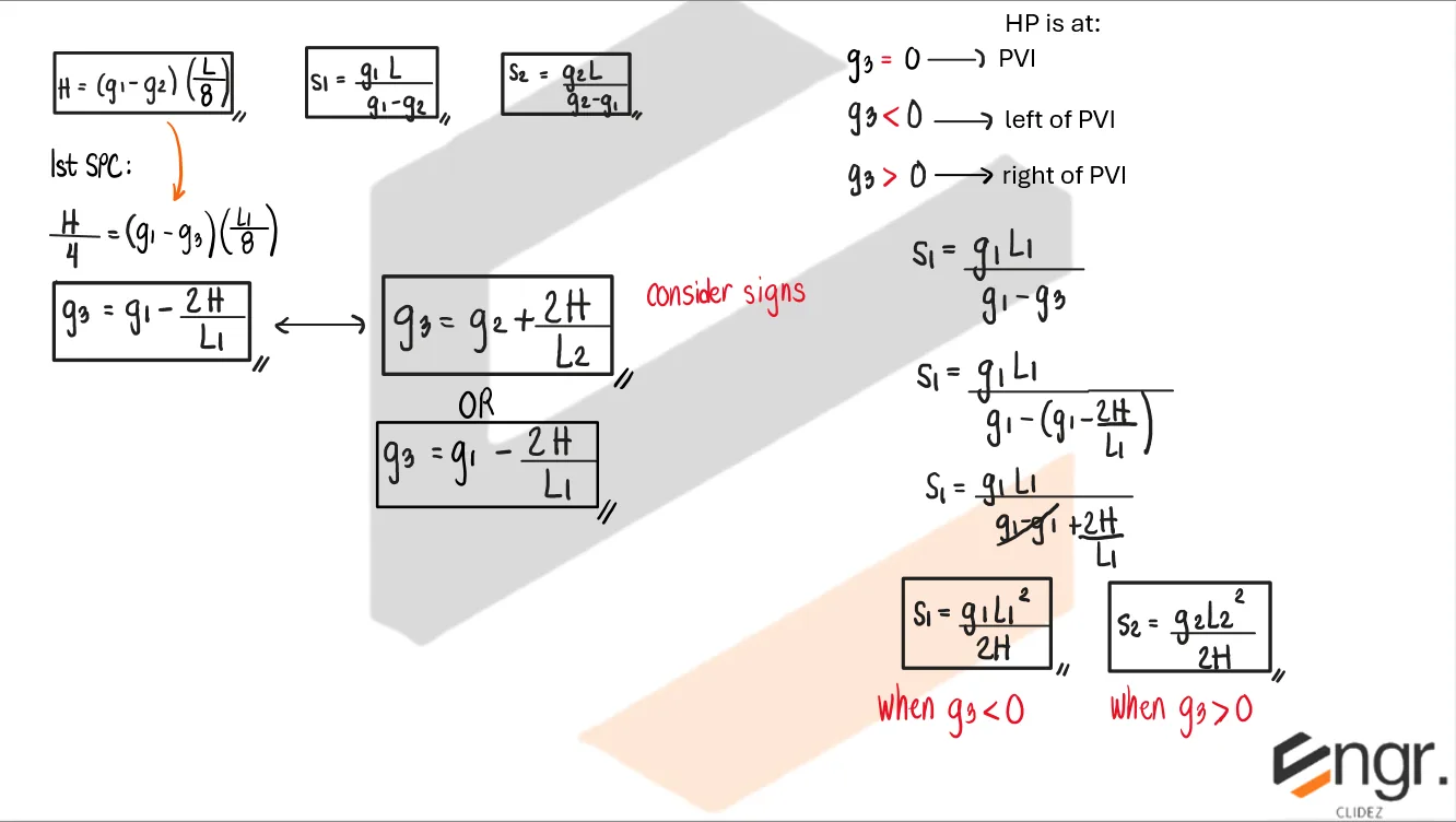
2. Location of Highest/Lowest Point (HP)
Grade at HP:
$$
g_3 = 0
$$
Interpretation (use algebraic signs throughout, including the sign of $H$):
Summit curve ($g_1 > 0$, $g_2 < 0$, $H > 0$):
$g_3 = 0$ → HIGHEST POINT is at PVI
$g_3 < 0$ → HIGHEST POINT is to the left of PVI
$g_3 > 0$ → HIGHEST POINT is to the right of PVI
Sag curve ($g_1 < 0$, $g_2 > 0$, $H < 0$):
$g_3 = 0$ → LOWEST POINT is at PVI
$g_3 > 0$ → LOWEST POINT is to the left of PVI
$g_3 < 0$ → LOWEST POINT is to the right of PVI
The rule reverses for sag because $H$ is negative when grades are treated algebraically. Equivalently, the extremum lies on whichever side of PVI the slope changes sign: on the left when $g_1$ and $g_3$ have opposite signs, on the right when $g_3$ and $g_2$ have opposite signs.
3. Relationship of Intermediate Grade
$$
g_3 = g_1 - \frac{2H}{L_1}
$$
OR
$$
g_3 = g_2 + \frac{2H}{L_2}
$$
Consider algebraic signs of grades.
4. Station to Highest/Lowest Point
Summit curve ($g_1 > 0$, $g_2 < 0$, $H > 0$):
If $g_3 < 0$ → HIGHEST POINT is on the left side of PVI, measured from PVC:
$$
S_1 = \frac{g_1 L_1^2}{2H}
$$
If $g_3 > 0$ → HIGHEST POINT is on the right side of PVI, measured from PT:
$$
S_2 = \frac{g_2 L_2^2}{2H}
$$
Sag curve ($g_1 < 0$, $g_2 > 0$, $H < 0$):
If $g_3 > 0$ → LOWEST POINT is on the left side of PVI, measured from PVC:
$$
S_1 = \frac{g_1 L_1^2}{2H}
$$
If $g_3 < 0$ → LOWEST POINT is on the right side of PVI, measured from PT:
$$
S_2 = \frac{g_2 L_2^2}{2H}
$$
Use algebraic signs of $g_1$, $g_2$, and $H$ in both formulas. The signs make $S_1$ and $S_2$ come out positive automatically for the valid side.
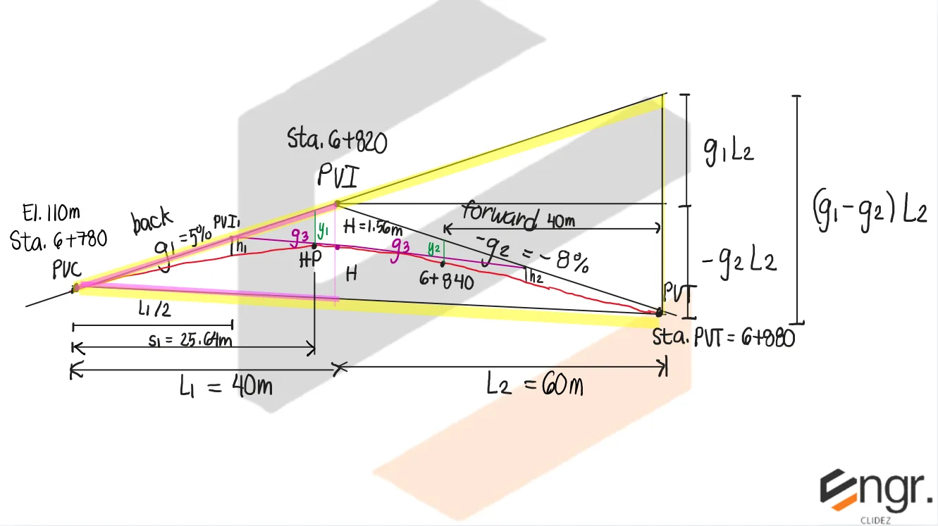
An unsymmetrical parabolic curve has a forward tangent of -8% and a back tangent of +5%. The length of curve on the left side of the curve is 40m long while that of the right side is 60m long. The PC is at station 6+780 and has an elevation of 110m.
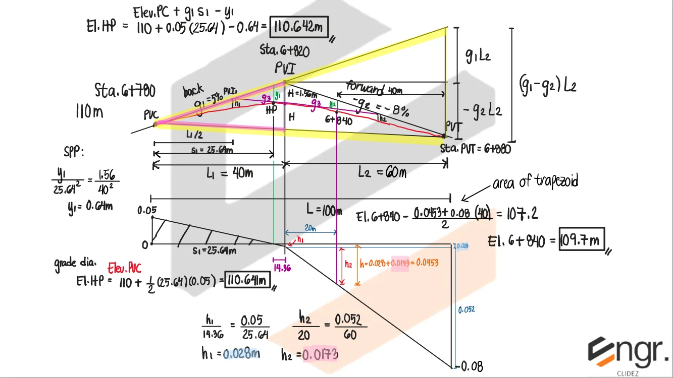
a. Determine the elevation of the highest point.
b. Determine the elevation at 6+840.
Step 1: Compute Maximum Offset $H$
$$
H = \frac{(g_1 - g_2)L_2 L_1}{2L}
$$
$$
H = \frac{(0.05 - (-0.08))(60)(40)}{2(100)}
$$
$$
H = 1.56 \text{ m}
$$
For the grade diagram in unsymmetrical parabolic curves, we do not connect the back tangent grade and the forward tangent grade using a straight line. Instead, we divide the diagrams into two. First, we plot the ordinate of the back tangent (+5% or +0.05), then we plot the ordinate of PVI (g3=-2.8% or -0.028), and we connect these two points with a straight line. Next, we plot the ordinate of the forward tangent (-8% or -0.08), and connect this to the ordinate of PVI using another straight line. The area under the diagram still defines the difference in elevation between two points, just like in symmetrical parabolic curves. Here, we compute the elevation of the highest point and the elevation at 6+840 using the grade diagram and verify that we still obtain the appropriate values. The small discrepancy is only due to rounding off error.
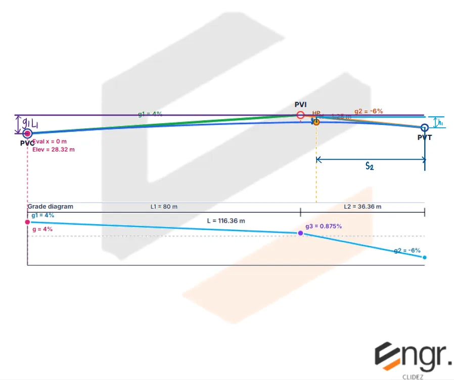
Problem: Unknown Total Length
An unsymmetrical parabolic curve has the following data:
H=1.25m
g1 = +4%
g2 = -6%
L1 = 80m (length of the left side of the curve)
Stationing of PVC: Sta. 2 + 070 with elevation of 28.32m
a. Determine the total length of the curve.
b. Determine the stationing and elevation of the highest point.
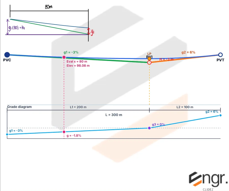
An unsymmetrical parabolic curve has a forward tangent of +6% and a back tangents of -3% intersecting at Sta. 10+020. The length of the curve on the left side is 200m while that of the right side is 100m. The elevation of PVC is 100m.
a. Compute the elevation of the curve at 9+900.
b. Compute the elevation of the lowest point of the curve.
c. Compute the elevation of PVI.
Given: $g_1 = -3\% = -0.03$, $g_2 = +6\% = 0.06$, $L_1 = 200 \text{ m}$, $L_2 = 100 \text{ m}$, $E_{PVC} = 100 \text{ m}$, $\text{Sta. }PVI = 10020$, and the required station is $\text{Sta. }9900$.
Step 1: Compute the curve height using algebraic signs.
$$
H = \frac{(g_1 - g_2)L_2L_1}{2(L_1 + L_2)}
$$
$$
H = \frac{(-0.03 - 0.06)(100)(200)}{2(200 + 100)}
$$
$$
H = -3 \text{ m}
$$
Since $H$ is negative, the PVI is below the curve, so this is a sag curve. Use algebraic signs, including the sign of $H$.
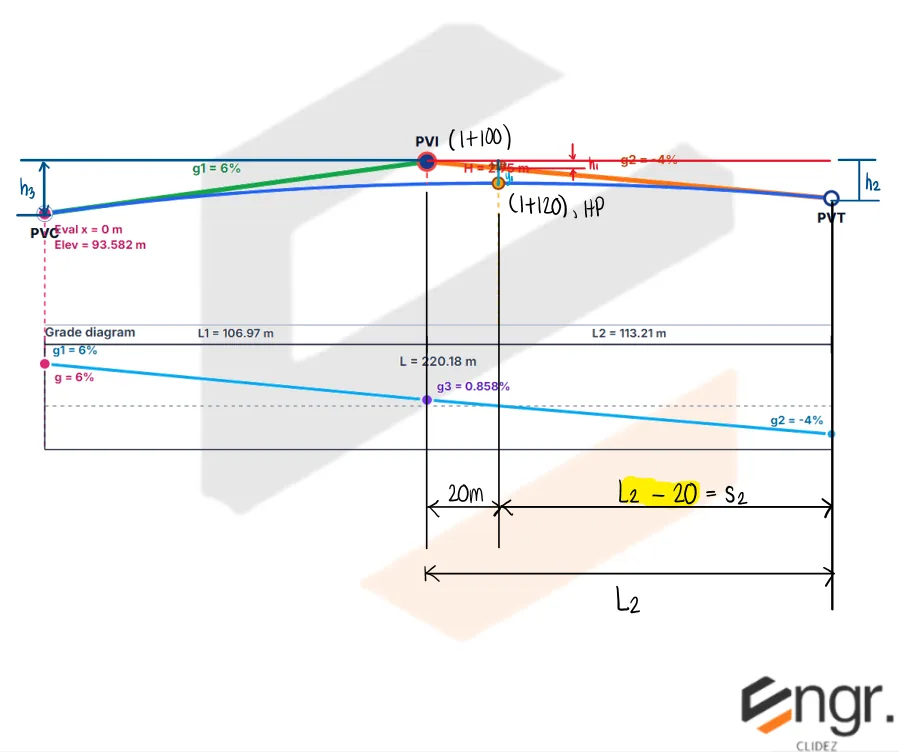
A back tangent having a slope of +6% is intersected by a forward tangent having a slope of -4% at Sta. (1+100) with an elevation of 100m. The two tangents are to be connected by a parabolic curve of height 2.75m. Due to terrain restrictions, the curve must have the highest elevation at Sta. (1+120).
a. Determine the length of the curve on the left side.
b. Determine the elevation of the highest point.
c. Determine the elevation of PVT.
d. Determine the elevation of PVC.
Given: $g_1 = +6\% = 0.06$, $g_2 = -4\% = -0.04$, $H = 2.75 \text{ m}$, and the highest point is $20 \text{ m}$ to the right of the PVI.
The quadratic gives two mathematical roots, but only the larger value is physically valid. From the height equation, $L = \dfrac{L_2^2}{L_2 - 55}$, so the total length is positive only when $L_2 > 55 \text{ m}$. The smaller root is less than $55 \text{ m}$ and would give an impossible negative total curve length.
$$
\boxed{L_2 = 113.20855 \text{ m}}
$$
Step 3: Solve for the total length $L$ and left length $L_1$.
An unsymmetrical vertical curve has L1 = 120 m and L2 = 180 m. Find the total length.
$$L=L_1+L_2=120+180=300\text{ m}$$
Answer: The total curve length is 300 m.
🧭 Jump to:
Scroll to zoom
Exam Generator Problems
Additional board-style practice items for this topic.
Question Bank: q767
MSTE - Highway Engineering / Unsymmetrical Parabolic Curves / Val
Formula-mode item rendered with fixed values for lecture/PDF export.
A forward tangent having a slope of -4% intersects the back tangent having a slope of +7% at point V at stations 6+300 having an elevation of 230m. It is required to connect the two tangents with an unsymmetrical parabolic curve that shall pass through point A on the curve, having an elevation of 227.57m at station 6+270. The length of the curve on the side of the back tangent is 60m.
NOTE:
For summit curves:
If g3<0, the highest point is to the left of PVI
If g3>0, the highest point is to the right of PVI
If g=0, the highest point is exactly at PVI
Determine the value of the maximum offset, H (in meters).
36.66687500000002
1.330317460317461
25.666812500000013
52.38125000000003
Determine the length of curve on the right side of PVI.
78.06133989754507
60.23615175317008
54.64293792828155
111.51619985363581
Solution pending in psadquestions/q767.json.
Question Bank: q768
MSTE - Highway Engineering / Unsymmetrical Parabolic Curves / Val
Formula-mode item rendered with fixed values for lecture/PDF export.
An unsymmetrical parabolic curve has a back tangent of -3.4% and a forward tangent of 6.6% intersecting at Sta. 10+480. The length of curve on the left side is 340m while that of the right side is 109m The elevation of PVC is 124m.
NOTE:
For sag curves:
If g3>0, the lowest point is to the left of PVI
If g3<0, the lowest point is to the right of PVI
If g=0, the lowest point is exactly at PVI
Compute the elevation of the curve at 10+357.
118.30308902135465
114.12108902135465
94.64247121708372
91.29687121708372
Compute the elevation of the lowest point of the curve.
116.49889711764706
93.19911769411766
145.62362139705883
115.90481834862386
Compute the elevation of PVT.
119.634
112.44
104.34481834862385
114.94808230588235
Solution pending in psadquestions/q768.json.
Question Bank: t1254
MSTE - Highway Engineering / Curves, Earthworks, and Traffic Engineering / Gemini mapped Chapter 7 to 10
An unsymmetrical parabolic curve has a forward tangent of -8% and backward tangent of +5%. The length of curve on the left side is 40 m long while that of the right side is 60 m long. PC is at Sta 6 + 780 and at elevation 110 m.
What is the grade of the common tangent?
3.2%
-3.2%
-2.8%
2.8%
Determine the stationing of the highest point.
6 + 810
6 + 805.64
6 + 808.32
6 + 806
Determine the elevation at Sta 6 + 820.
110.44 m
112.11 m
109.33 m
108.12 m
Solution pending in psadquestions/t1254.json.
Question Bank: t1267
MSTE - Highway Engineering / Curves, Earthworks, and Traffic Engineering / Gemini mapped Chapter 7 to 10
A car skidded going into an intersection, struck a pedestrian, and continued until it hit a tree. Based on the damage to the front of the car, it is estimated that the car was doing 10 kph at impact with the tree. The length of the skid marks was measured at 42 m. The road is on a downhill grade of -5 per cent. A test car skidded 15.5 m on the same section of rod when braked from a speed of 45 kph to a halt.
What is the coefficient of friction between the tires and the pavement?
0.632
0.521
0.564
0.478
What is the probable speed of the car involved in the accident when the brakes were applied, in kph?
85
70
75
90
If the perception-reaction time of the driver is 1.5 seconds, what could have been his minimum total stopping distance to avoid the crash?
74 m
45 m
62 m
81 m
Solution pending in psadquestions/t1267.json.
Question Bank: t1298
MSTE - Highway Engineering / Curves, Earthworks, and Traffic Engineering / Gemini mapped Chapter 7 to 10
A topographic survey of a proposed highway shows that the centreline crosses a small valley between Station 20 + 033 (Elevation 75 m) and Station 20 + 071 (74.5 m). The bottom of the valley is at Station 20 + 048 (Elevation 63.2 m). The grade line of the proposed highway passes the ground points at the edges of the valley (Sta. 20 + 033 and Sta. 20 + 071) and the section at any of these stations are three-level sections with width of road base of 10 m and side slope of 2:1. The sides of the valley can be assumed to slope directly to the lowest point from the edges.
What is the cross-sectional area at Station 20 + 048 in m^2?
331.2
421.7
352.3
387.6
What is the volume of fill from Station 20 + 033 to Station 20 + 048, in cubic meters?
2,710
3,540
2,230
2,560
What is the volume of fill from Station 20 + 048 to Station 20 + 071, in cubic meters?
3,419
3,247
5,856
4,847
Solution pending in psadquestions/t1298.json.
Question Bank: t1339
MSTE - Highway Engineering / Curves, Earthworks, and Traffic Engineering / Gemini mapped Chapter 7 to 10
The number of vehicles passing a reference point per unit of time, and is measured in vehicles per hour.
density
flow
traffic
pedestrian
Solution pending in psadquestions/t1339.json.
Question Bank: w89
MSTE - Highway Engineering / Curves, Earthworks, and Traffic Engineering / MSTE November 2019
A wheel tractor-scraper weighing 91 tons is operated on a haul road with a tire penetration of 5 cm. What is the total resistance and effective grade when the scraper is ascending a slope of 5%?
MSTE - Highway Engineering / Curves, Earthworks, and Traffic Engineering / MSTE November 2019
This sign informs and advises road users of the directions, distances, routes, the location of services for road users, and points of interest.
advance direction sign
guide sign
traffic instruction sign
crossroad sign
Guide signs provide road users with information on routes, directions, distances, points of interest, and the location of services. They are typically rectangular with white lettering on a green or blue background. $\boxed{\text{guide sign}}$