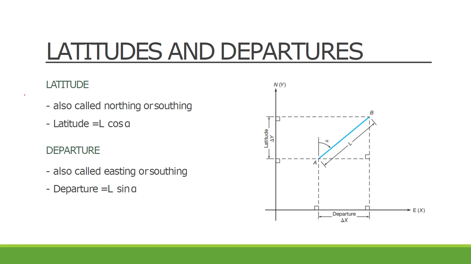
Departures and Latitudes
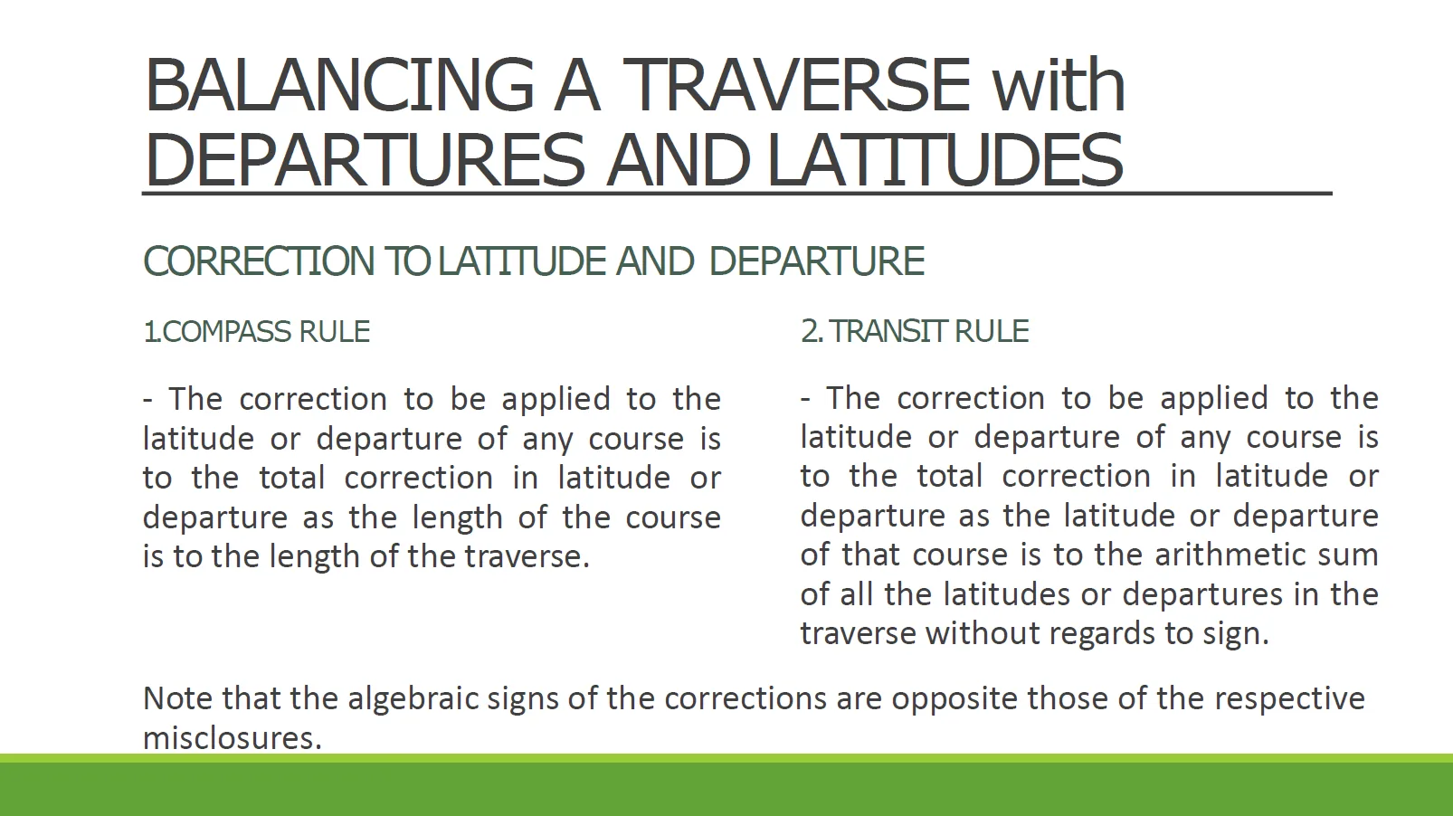
Correction Formula for Compass Rule
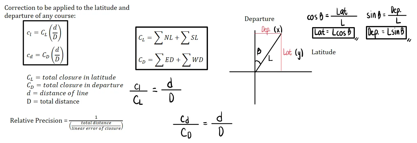
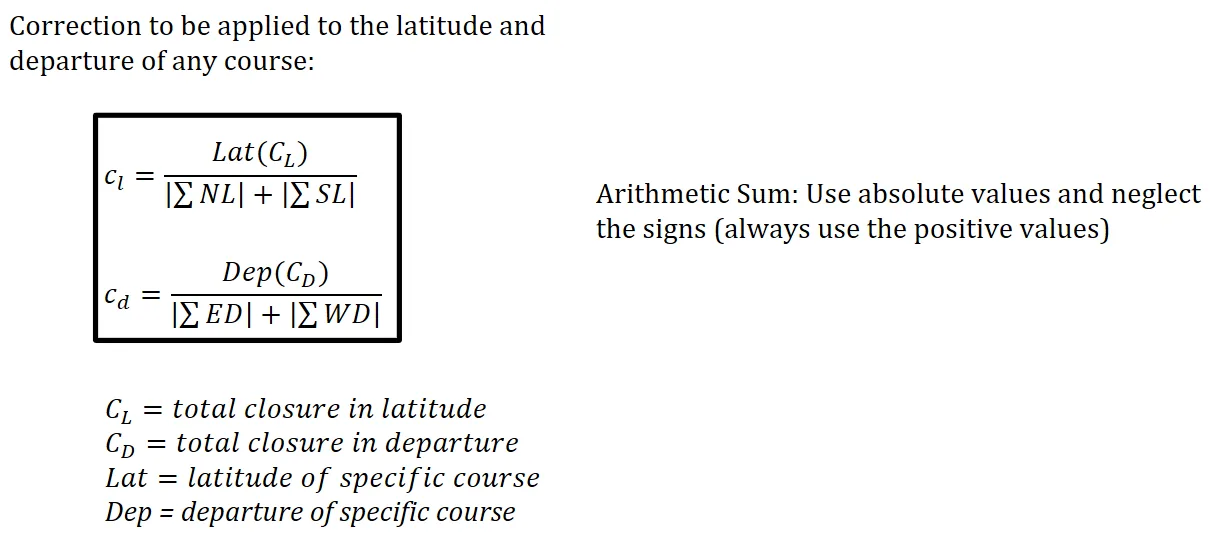
Correction Formula for Transit Rule

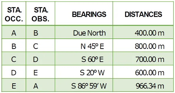
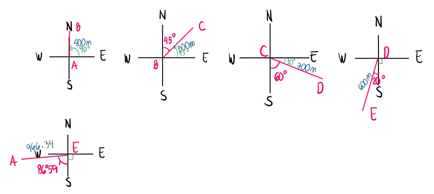
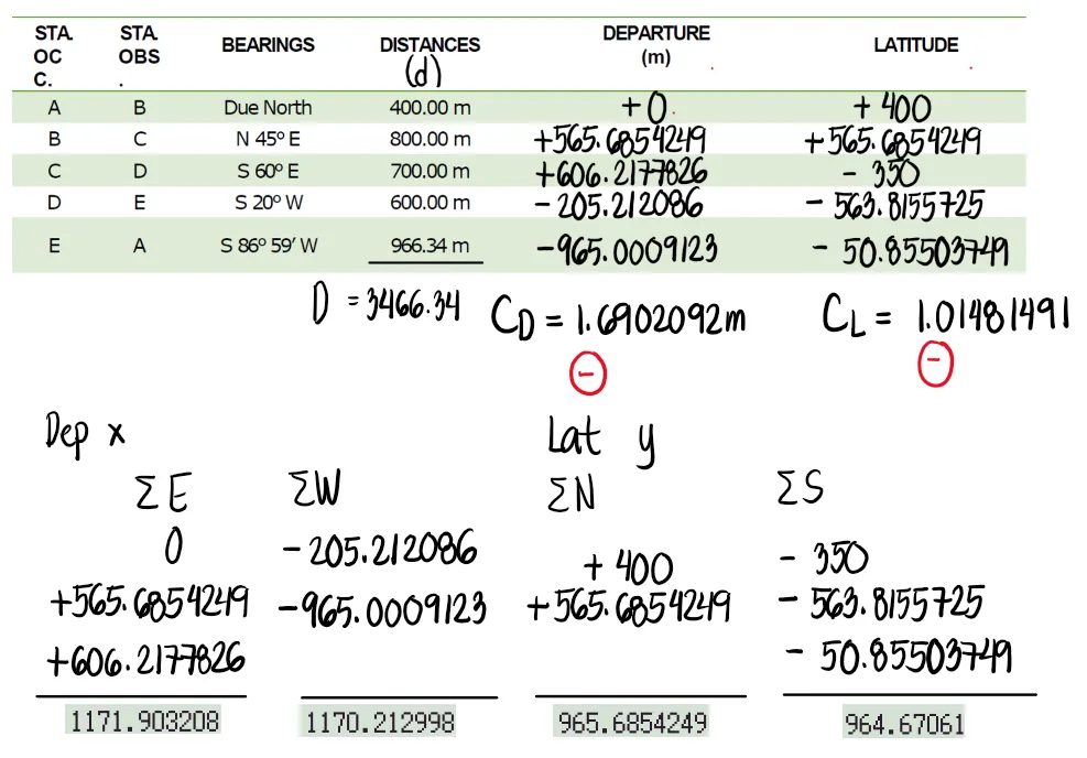
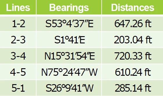
From the field notes of a closed traverse shown:
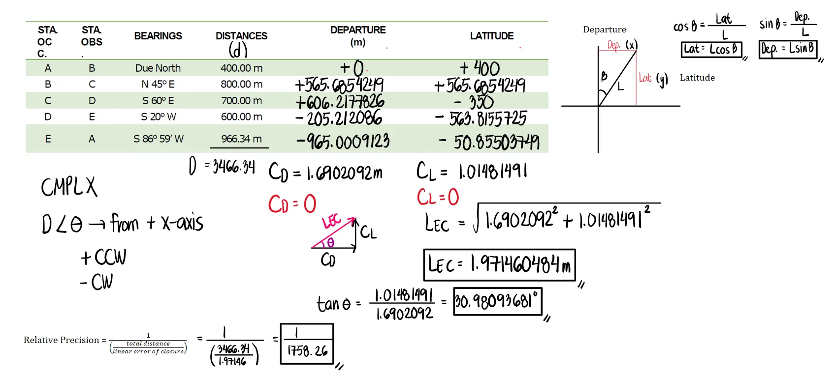
a. Compute the error of closure
b. Compute the relative precision of the traverse
c. Compute the adjusted distances and bearings of the lines using the compass rule


To model our figure, let us first sketch each line separately.
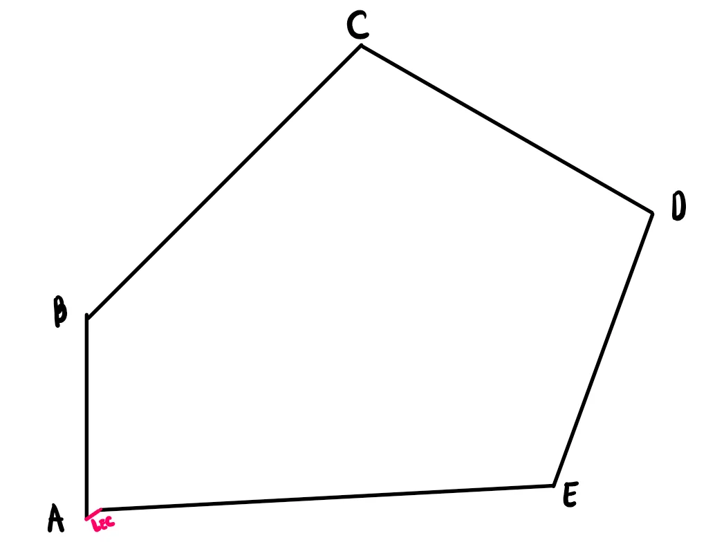
Connecting all of the lines, we obtain the following figure. If one models the figure using AutoCad, line EA will not yet connect back to point A. There will be some gap, and this gap between point A and E is called the linear error of closure.
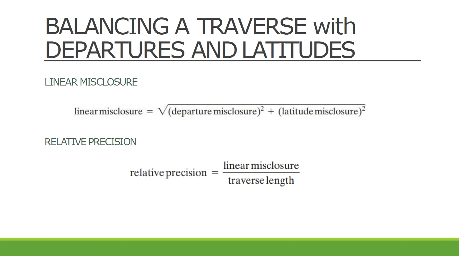
The concept utilized here is similar to that of resultants in Statics of Rigid Bodies. The line that connects the first point (A) and the last point (E) is the resultant if we talk about forces. In the context of surveying, however, this is referred to as the linear error of closure.
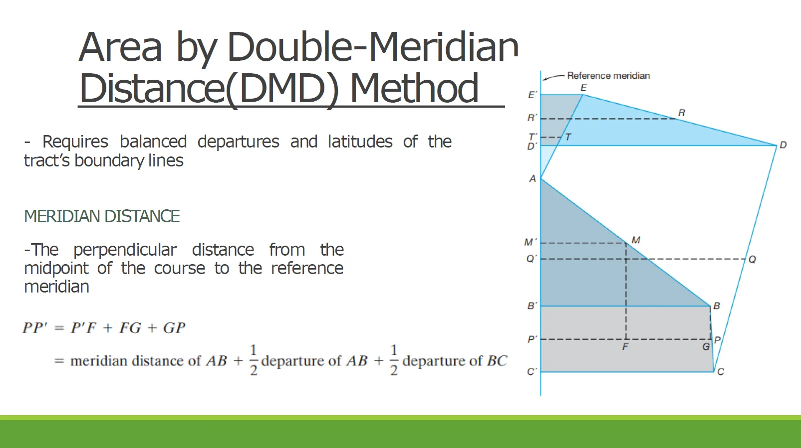
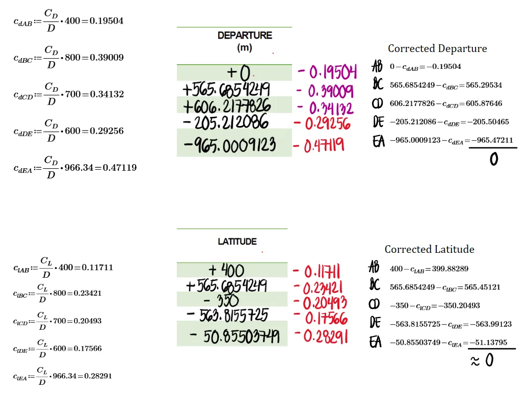
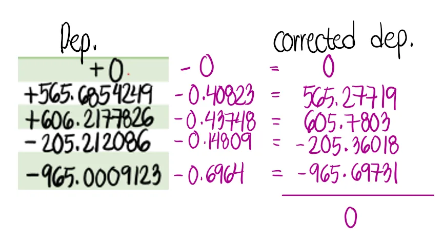
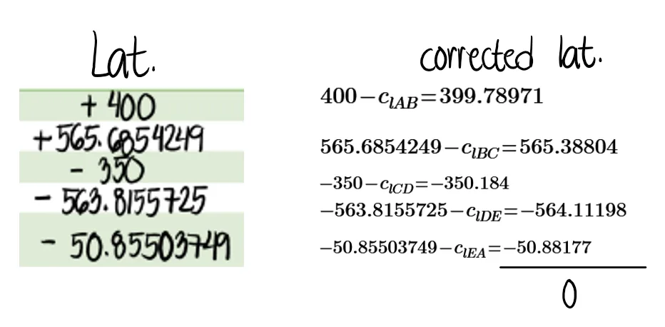
The linear error of closure will simply be the hypotenuse of the triangle formed by the sum of the departures and latitudes. We also solve the angle using the relationship between the two sides. Note that CD and CL are both positive. Hence, we subtract the corrections to the departures and latitudes so that the new summation will result to zero.
Let us focus on the sum of east departures. The result is 1171.903208m. Then, for the sum of west departures, the result is -1170.212998m. Notice that if we add both of them, the result will not be zero. To "close" the traverse, the sum should be equal to zero. To do this, we take away some value from 1171.903208m and add to the magnitude of -1170.212998m. Only when both east and west departures become equal in magnitude and opposite in signs will the correction become zero. To simplify the process, if CD or CL is positive, we subtract the corrections to each departure or latitude. If CD or CL is negative, we add the corrections to each departure or latitude.
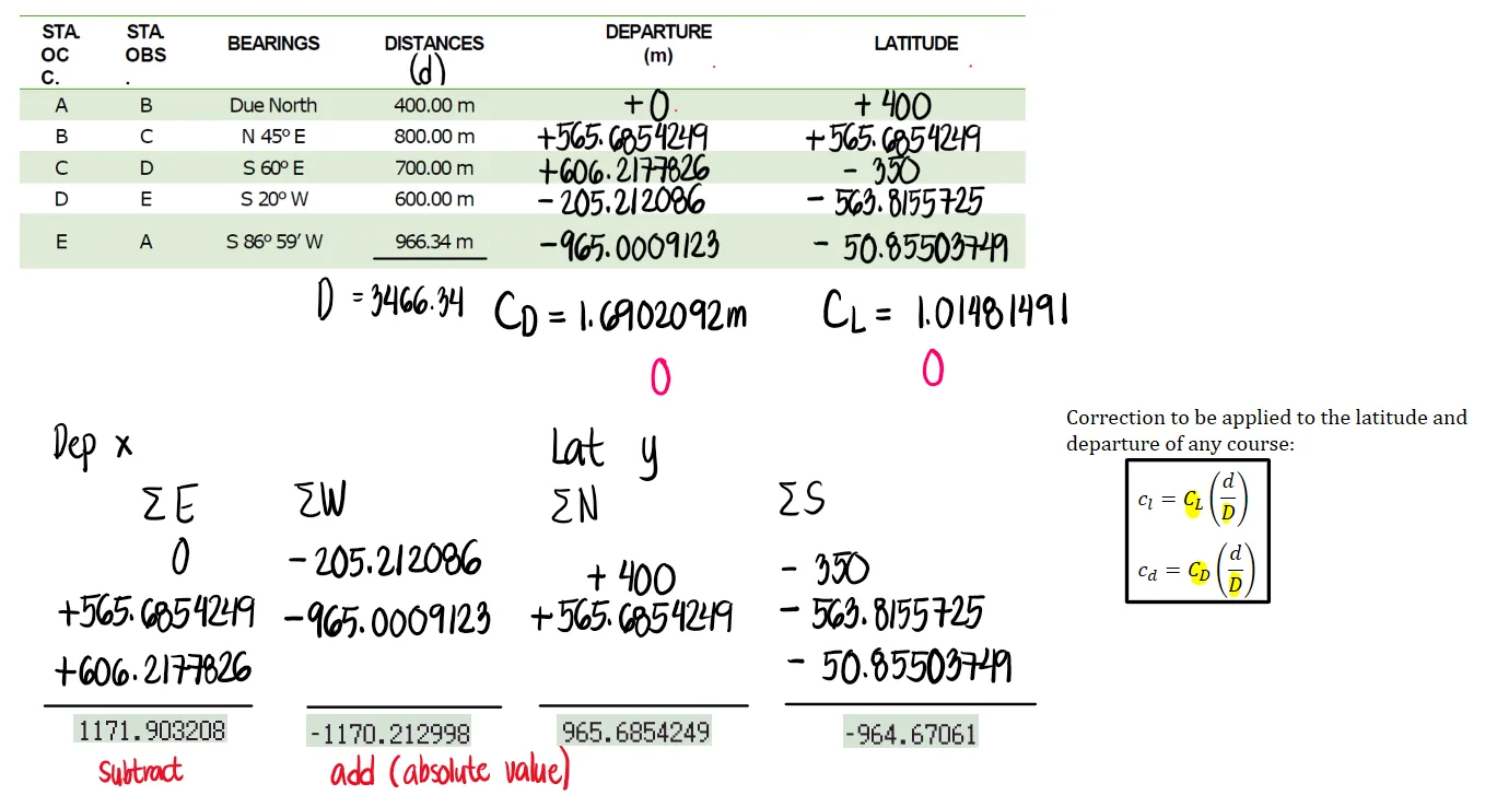
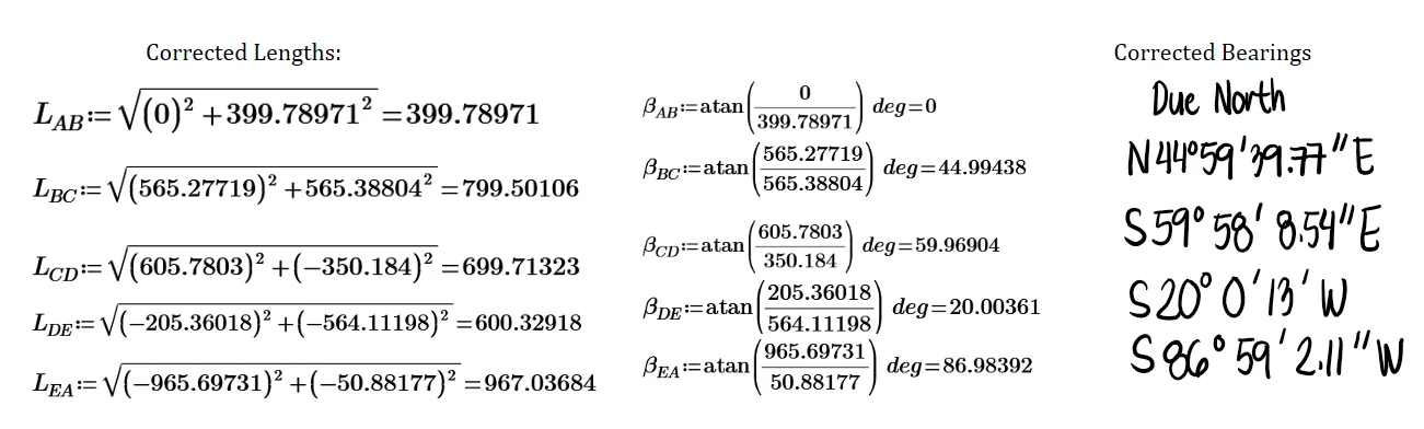
The corrected departures and latitudes are shown below. Note that to check whether all calculations are correct, we can sum up the new departures and latitudes. If the result is zero, then the new linear of closure will also be zero.
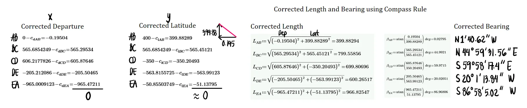
Below are the corrected distances and bearings. If one models the following data using AutoCad, line EA will connect back to point A with a linear error of closure virtually equal to zero.
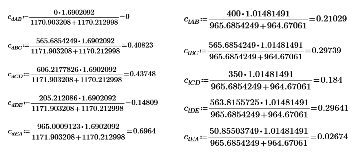
Compute the adjusted distances and bearings of the lines using the transit rule


Here we use the arithmetic sum (neglecting the signs and using only the absolute values) when we sum up the north and south latitudes as well as the east and west departures.
Next, we use the correction formula for transit rule for each departure and latitude.
When we sum up the corrected departures and latitudes, the result must be zero. This signifies that the linear error of closure will also be zero, which ensures that the traverse is closed.
The corrected lengths and bearings using the transit rule are shown below. Note that the results here differ from the compass rule, but only by a small amount.
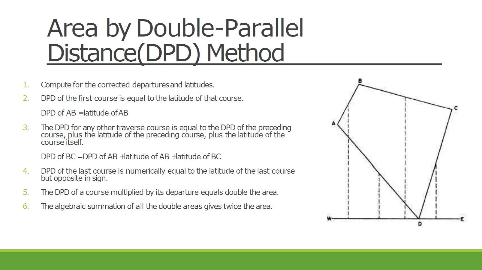
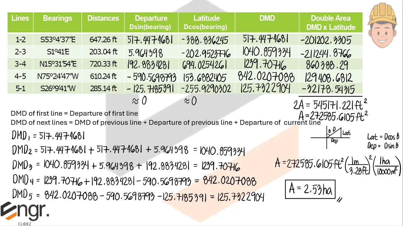
Given below is the technical description of lot 2081, Cebu Cadastre. Compute the area of the lot (in hectares) by DMD method.


Note here that the DMD of the last line must be numerically equal to the departure of that line, but with opposite sign. However, there is some discrepancy due to the linear error of closure not being exactly zero.


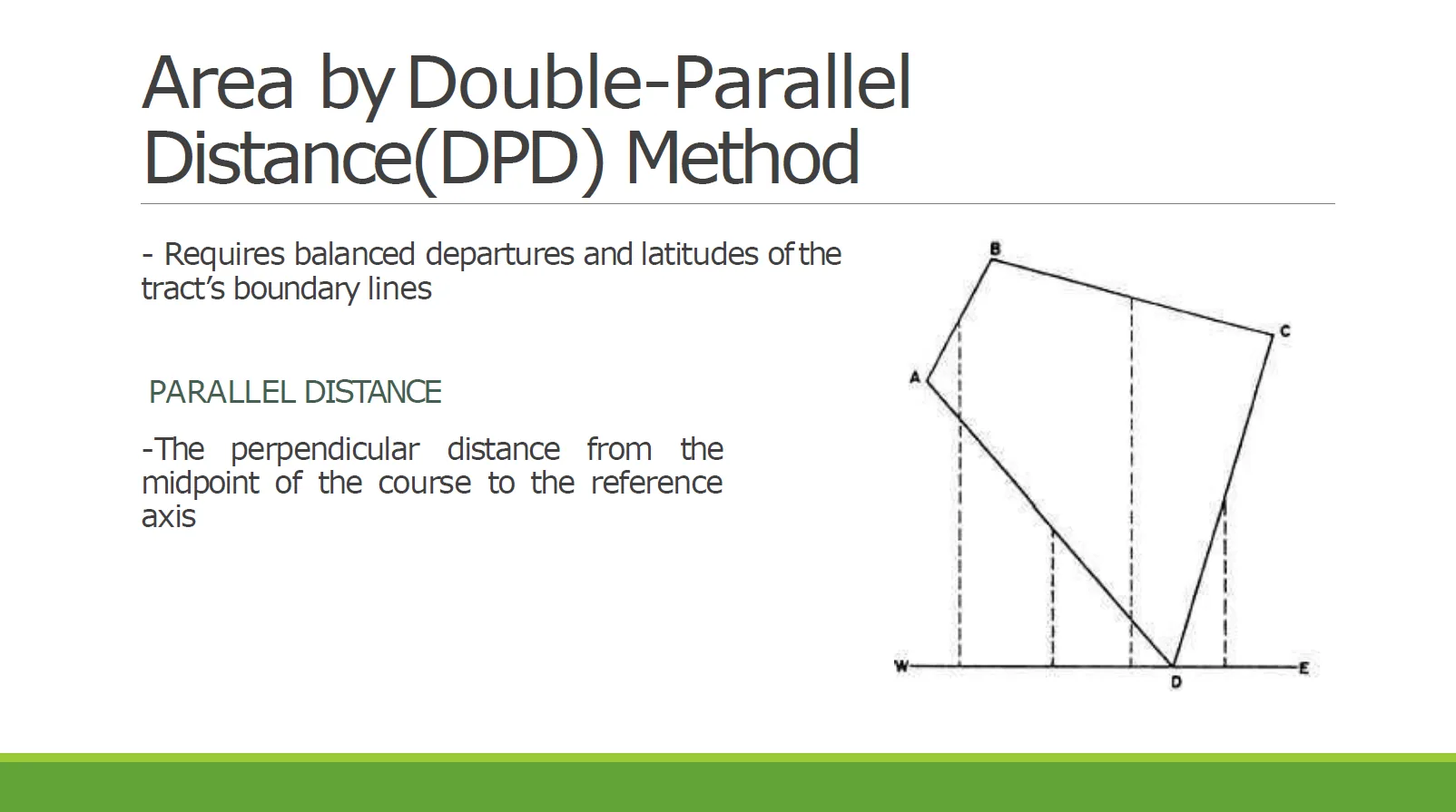
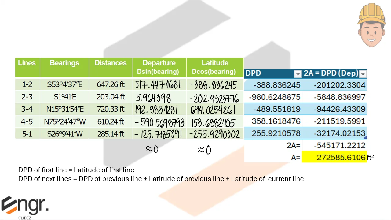
Resolve the area in Problem 3 using DPD method.


Note here that the DPD of the last line must be numerically equal to the latitude of that line, but with opposite sign. However, there is some discrepancy due to the linear error of closure not being exactly zero.


Refer to the image shown:


See images:


Refer to the image shown:


See images:


Refer to the image shown:


See images:


Refer to the image shown:


See images:


Additional board-style practice items for this topic.
An engineer setup his transit inside a triangular lot ABC and recorded the following data for corners A, B, and C of the parcel: [Corner OA: Bearing N 78.23° E, Distance 58.63 m; OB: S 42.25° W, Distance 85.24 m; OC: N 46.32° W, Distance 68.55 m].
What is the area of the parcel in sq. m.?
What is the length of side AB in meter?
What is the bearing of side AB?
Solution pending in psadquestions/t1130.json.
A surveyor sets up a transit at a point Q which is at the middle portion of a four-sided tract of land and reads the bearings and measures the distances, as given below. [Table omitted]
What is the length of side BC in meters?
Determine the bearing of side BC.
What is the area of the land in hectares?
Solution pending in psadquestions/t1137.json.
A closed traverse has the following information: Summation of N & S latitudes = +1.32 m, Summation of E & W departures = -1.85 m, Total latitude = 1856.32 m, Total departure = 1532.47, Perimeter of traverse = 6235.24. Line BC on this traverse has the following data: Length = 652.32, Latitude = 523.65 m N, Departure = 388.99 m E.
What is the correction to be applied to the latitude of BC using the transit rule?
What is the correction to be applied to the departure of BC using the compass rule?
What is the corrected latitude of BC using the compass rule?
Solution pending in psadquestions/t1156.json.
A closed traverse has the following data: [Line 1-2: Latitude 75.54, Departure 44.35; 2-3: -4.40, ----; 3-4: -50.85, 23.93; 4-5: -101.25, -18.89; 5-6: -24.28, -48.49; 6-1: ----, -33.00].
What is the length of line 2-3?
What is the bearing of line 2-3?
What is the DMD of line 5-6?
Solution pending in psadquestions/t1169.json.
A series of perpendicular offsets were taken from a transit line to a curved boundary line. These offsets were taken 10 meters apart in the following order: 0, 1.6, 3.4, 3.8, 5.9, 6.5, 5.7, 4.2, 2.4, 1.1, 0.
Determine the area included between the transit line and the curved line using Trapezoidal Rule.
Determine the area included between the transit line and the curved line using Simpson's One Third Rule.
Solution pending in psadquestions/t1182.json.
Find the area (in m^2) of the given cross-section if the width of roadway is 12 m. [Left: 9.8 / 3, Center: 0 / 2.8, Right: 11.2 / 4.89]
Solution pending in psadquestions/t1270.json.
Given the cross section of a proposed road to be constructed, find the cross-sectional area in sq. m. The base of road is 6m and the side slopes are 1.25:1. [7.80 / +3.84, 2.00 / +2.42, 0 / +4.25, 4.00 / +2.50, 5.65 / +2.12]
Solution pending in psadquestions/t1279.json.
The areas in cut of two irregular sections 80 m. apart are 128 m^2 and 245 m^2, respectively. Both sections are three-level sections with base width of 8 m and side slope of 3H:2V. Assume the ground slope uniformly between the two sections and use the prismoidal correction formula.
What is the depth of cut at section 2?
What is the volume of cut by end-area method in m^3?
What is the volume of cut in m^3 using the prismoidal correction formula?
Solution pending in psadquestions/t1285.json.
The cross-section notes of a ground to be excavated for a proposed roadway is given next. The roadway is 10 meters wide with side slope of 3:2. [Station 3+000: 8L / ?, 0 / 3.2, 12.8R / ?; Station 3+060: 8.9L / ?, 0 / 2.6, 10.4R / ?].
What is the cross-sectional area at Station 3+000?
What is the volume by end-area method in m^3?
What is the volume by prismoidal formula in m^3?
Solution pending in psadquestions/t1291.json.
An offshore barrier that protects a harbor or other coastal area from the full force of the sea.
Solution pending in psadquestions/t1336.json.
A surveyor sets up a transit at point $P$, which is at the inner portion of a four-sided tract of land $ABCD$, and reads the bearings and measures the distances as follows:
| Line | Bearing | Distance |
|---|---|---|
| PA | N 40°30' W | 420.35 |
| PB | N 38°00' E | 530.15 |
| PC | S 70°00' E | 480.75 |
| PD | S 60°15' W | 695.10 |
Determine the corrected values for the latitude of line $BC$ and departure of line $CD$ using the compass rule.
| Course | Bearing | Length |
|---|---|---|
| AB | N 26°10' E | 285.10 |
| BC | S 75°25' E | 610.45 |
| CD | S 15°30' W | 720.45 |
| DE | N 1°42' W | 203.00 |
| EA | N 53°06' W | 647.02 |